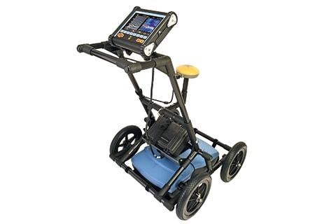
Ground Penetrating Radar
Ground Penetrating Radar (GPR) uses high-frequency radio signals transmitted into the ground with reflected signals returned at the receiver. The receiver measures the time taken for a pulse to travel to and from the target to accurately interpret the depth and location of the underground utility. Once the data has been collected and interpreted by the onboard system, real-time data can be accessed and distributed as required.
(GPR) Applications
Non-conductive pipes and conduits
-
-
- GPR detects ceramic and plastic pipes and conduits not containing a tracer wire or sondes
-
Unknown Utility Locate
-
-
- Using a grid pattern scan of the site will identify buried tanks and any underground hazards and obstructions.
-
Survey Reporting
-
-
- Radar images can be used to appropriate software for analysis and use in survey reports. Information collected can be used to determine asphalt thickness, subgrade depth, etc.
-
Electromagnetic Utility Locate (EM)
The RD8100 is an advanced line locating and fault system possessing the capability of locating and fault finding at the same time using a single hookup. Containing a unique arrangement of 5 antennas, the RD8100 delivers locate accuracy and unmatched precision when locating buried underground utilities by transmitting and receiving set frequencies to locate and determine location and depth.

Electromagnetic Locators are commonly used for tracing conductive pipes and conduits using separate transmitters and received to locate utilities. The transmitter sends a given frequency that induces secondary fields in nearby pipes and cables. The receiver detects these fields and accurately locates and traces buried underground utilities.
EM Applications
Telecommunications
-
-
- Transmitting a given frequency to the cables or associated conduit enables the receiver to determine location and depth
-
Buried Electrical
-
-
-
- The locator transmits a given frequency into both energized and non-energized lines resulting in the identification of location and depth of the buried underground utility.
-
-
Gas Lines
-
-
-
-
- The transmission of a given frequency is received and interpreted to provide depth and location of the buried underground utility.
-
-
-
Water Lines and Storm and Sanitary Sewer Lines
-
-
-
- When made of a conductive material or possess a tracer wire, the EM Locator’s transmitter and receiver determine depth and location by sending and receiving given frequencies.
-
-